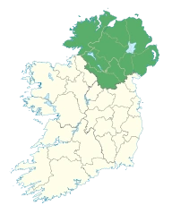
Location of Ulster
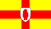
Flag of Ulster
Ulster (Ulaidh or Cúige Uladh, is one of the provinces of Ireland, located in the north of the island.
Geography[]
Ulster has a population of just over 2 million people and an area of 21,552 square kilometres (8,321 sq mi). Its biggest city, Belfast, has an urban population of over half a million inhabitants, making it the second-largest city in Ireland and the 10th largest urban area in the UK.
Six of Ulster's nine counties, Antrim, Armagh, Down, Fermanagh, Londonderry and Tyrone, form Northern Ireland which remained part of the United Kingdom after the partition of Ireland in 1921. Three Ulster counties – Cavan, Donegal and Monaghan – form part of the Republic of Ireland. About half of Ulster's population lives in counties Antrim and Down.
Religion[]
Across the nine counties, according to the aggregate UK 2011 Census for Northern Ireland, and Irish 2011 Census for counties Cavan, Donegal and Monaghan, there is a slim Catholic majority over Protestant (50.8% against 42.7%).
Counties[]
| County | Population | Area |
|---|---|---|
| County Antrim | 618,108 | 3,046 square kilometres (1,176 sq mi) |
| County Armagh | 174,792 | 1,254 square kilometres (484 sq mi) |
| County Cavan | 73,183 | 1,931 square kilometres (746 sq mi) |
| County Donegal | 161,137 | 4,861 square kilometres (1,877 sq mi) |
| County Down | 531,665 | 2,466 square kilometres (952 sq mi) |
| County Fermanagh | 61,170 | 1,691 square kilometres (653 sq mi) |
| County Londonderry | 247,132 | 2,075 square kilometres (801 sq mi) |
| County Monaghan | 60,483 | 1,295 square kilometres (500 sq mi) |
| County Tyrone | 177,986 | 3,263 square kilometres (1,260 sq mi) |
| Grand Total | 2,105,656 | 21,882 square kilometres (8,449 sq mi) |
- Counties shaded in grey are in the Republic of Ireland.
- LeinsterCounties shaded in pink are in Northern Ireland.